By Jo Nova
People with a good education are hard to fool, which is why the curriculum buries the good stuff until it disappears under a kiloton of culture, engagement and sustainability blah. Then the media (with US government Blob funding) repeats the hypnotic trance line “seas are rising due to climate change” until anyone who was accidentally taught real science, forgets it.
How many children (how many adults) think that sea levels have been the same for a million years? The travesty of 12 years of education is that 99% of people know nothing about 99% of history, and even less about prehistory. Every one of these defenseless souls is so easily fooled into panic attacks about seas rising a millimeter a year. “Unprecedented” they say! Don’t use the hair-dryer!
Willie Soon has some fun in his time machine zipping through ancient Greece and Roman history, where ports were built 6 crazy kilometers from the sea…
As Willie mentioned, it’s awkward that the rise started 100 years before cars, and coal power plants existed.
And after two world wars, 1.5 billion cars and 35 million planes a year, the rate of sea level rise is pretty much the same as it was in 1860 or so. It’s like we are irrelevant…
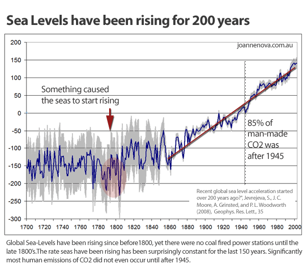
[Graphed by Joanne Nova based on data from Jevrejura et al located at this site PMSML]
The fact is, according to 1000 tide gauges, spread all over the globe, sea levels are rising slowly at around 1 sole mm a year. And a nerd-level intense study of 60 beaches in Northern Europe showed a similar rise. By a strange coincidence the Topex/Poseidon satellite sea-level data set also showed the same tiny rates of sea level change in the 1990s — right up until they tortured the data to fit climate models. (We hear they calibrated the satellites to one sinking gauge in Hong Kong).
Other posts on Sea Levels
- Sea level rise less than 1mm for last 125 years in Kattegatt, Europe — Nils-Axel Morner
- Are sea-levels rising? Nils-Axel Mörner documents a decided lack of rising seas
- Man-made sea-level rises are due to global adjustments (Envisat data is also adjusted up).
- It wasn’t CO2: Global sea levels started rising before 1800
- 10% of sea level rise is due to land rising too. Got that?
- South Pacific sea levels – Best records show little or no rise?!
- Mass carbon emissions, yet Australian sea levels rise at similar speed as 1920 – 1950
- Climate change creates free real estate in Tuvalu: “climate refugees” can all go home
- Rising sea-levels in the Indian Ocean due to man-made “adjustments” not CO2
- Kiribati sinking “like Titanic” but 59 million times slower
- Asian sea levels changed rapidly 6,000 years ago — natural sea level rise “unprecedented”


Does Willie really think that an increase in temperature leads to an instant rise in sea level? The time lag is decades because of thermal mass. Why don’t you show some more recent data? Sea level rise is nonlinear and there is clear evidence of acceleration.
480
Prove the evidence of acceleration!
You will be sure for the Nobel Price when you have success 😀
520
https://tamino.wordpress.com/2025/02/25/acceleration-of-sea-level-rise/#more-12412
348
How can these satellites, whizzing by over 1300 kms up, measure ocean SLR to millimetre accuracy? Even the satellite specs themselves clearly show that they cannot measure to this accuracy level. It’s all done with adjustments and modelling, not actual measurements.
551
Goolag AI has a known extreme Left, pro-climate-catastrophism propaganda slant and says the following about the accuracy of satellite sea level measurements. It is quite bizarre.
Firstly, it says the accuracy is “a few centimetres” then says “this allows scientists to monitor sea level rise with millimeter-level accuracy”.
How do they make the leap from a “few centimetres” accuracy to “millimeter-level”?
490
Sentinel-6 accuracy is specced at “Combined standard uncertainty is 3.46cm for LR ALT-NRT products and 3.35cm for HR ALT-NRT products”.
NRT: Near Real Time
ALT: Altimetry
LR: Low Resolution
HR: High Resolution
For the full data, look for “EUMETSAT Sentinel-6 End-User Requirements Document”
180
How do they eliminate waves higher than 3.35 cm?
140
Simon, thanks for showing the updated graph which proves my point.
You cherry-pick the last 30 years, but look at the ups and downs in sea level back to 1860.
Obviously, we are not seeing anything today that is outside normal variation. Obsessing over the last 30 years when there are known 30 and 60 year and longer cycles in natural shifts in sea level is just reading tea-leaves. These scientists are embarassing.
The graph Simon wants us to see (done with “adjusted” satellites).
If, say, changes on the Sun were driving long multi-hundred year cycles of sea level rise, the graph would look a lot like sea levels started rising in the late 1700s and keep right on going with small variations up and down thanks to the PDO, AMO etc.
DATA: Global mean sea level time series from Integrated Multi-Mission Ocean Altimeters TOPEX/Poseidon, Jason-1, OSTM/Jason-2, and Jason-3 Version 5.1. Ver. 5.1 PO.DAAC, CA, USA is available https://podaac.jpl.nasa.gov/NASA-SSH and from https://doi.org/10.5067/GMSLM-TJ151.
110
I’m not sure what your point is. Your chart starts after 1990. Sea level rise is nonlinear and has been accelerating.
01
And likewise it “accelerated” in the 1790s, the 1860s and the 1940s too. Which of those was due to CO2? And which was caused by a natural factor that you can’t name?
If you don’t know what drives the natural cycles, you can’t explain the latest rise which is similar. It could be the same mystery factor. Eg Solar electric. Solar Magnetic. Solar spectral changes, or solar wind. Or something else…
30
I take it that a few centimetres is 3 centimetres. I reckon that is just about there, that’ll do, she’ll be right type science. As you say David a transition from a few centimetres to millimetres is astounding. Give them an inch and they’ll take a mile.
260
Measurement error decreases with number of observations. Systemic error can be corrected through calibration.
146
Simon:
Taking more measurements improves precision (closeness of repeated measurements to each other, reduced standard deviation) by averaging random measurement fluctuations.
It does not improve accuracy (closeness to true value) which is determined by the capability of the measuring instrument as determined by physical limitations of the machine.
431
Simon, David has explained it better, but may I add that unless you have a known reference, how do you determine the error? Something to ponder.
180
That only works if the error really is systematic (hint, equipment is subject to drift, which may not be linear) and calibration requires some other reference more accurate than the device being calibrated. Did they send a team up to do regular calibration checks on each satellite? If not, why not?
00
“How do they make the leap from a “few centimetres” accuracy to “millimeter-level”?”
It’s the magic of homogenization.
90
As we know with mathematical models GIGO, garbage in, garbage out.
Also what is the margin of error for remote sensing, bet it’s more than 1 millimeter.
160
About 4mm. Sea level rise is currently about 4mm/year so the measurement error argument is irrelevant.
130
Simon,, No, SLR is NOT 4mm/year. At Fremantle, one of the world’s longest-serving tidal gauges, it’s 1.7mm/year. Go to the website and check it yourself. Then also check Sydney’s gauge average.
For Freo, the total SLR over the last 120 years is less than its daily tidal range.
170
Contrary to what you might think, there is more to the world than just Sydney and Perth.
121
Simon, you didn’t specify a location for your generalised statement, so I assumed Australia. Ok, exactly WHERE is this global location for this 4mm/year SLR? Then we can check to understand why this is so.
There are usually valid reasons why some locations have higher or lower SLR, as has been discussed by other commentators.
140
Actually Sydney and Perth are reasonably good. Australia is rotating around an axis that runs across the country, so the far north and far south are the ones most likely to suffer from the “tilt” of the crustal plate. Both cities have reasonably long records, though Perth is subsiding which means the measured figure exaggerates true sea level rise.
70
It was Simon’s team who assured us that we would have 50 million climate refugees by, when was it? 2005? 2010?
A time long gone, anyway. The latest head count is none
101
It is called “Statistics”, and it is NOT AN EXACT SCiENCE.
If the gradation on you measure is 1 cm, if you take aa reading your accuracy is to 1 cm.
Take ten readings and average them, t he “accuracy” of that average can be reported as to 0.1 cm
Fun, eh? What?
30
I asked for a proof, not for an activist memo.
😀
360
Do you trust NASA? https://climate.nasa.gov/vital-signs/sea-level/?intent=121
033
Actually Simon, NO.
310
No. Tony Heller has explained why.
But NASA will again become trustworthy and competent under the TRUMP Administration with the new Administrator. The current TRUMP-appointed acting administrator is Janet Petro (a competence placement, not DEI).
300
and yet you’re willing to trust a conspiracy theorist operating under a pseudonym who denies mass shooting events.
129
You know that all, no exception, “Corona conspiracy theories” turned to be correct?:D
If someone like you come among with “conspiracy theorist” I’m more than alerted 😀
40
The space side of NASA is ok, it’s their Cambridge University NOAA branch that needs a complete overhaul.
150
You’ve got your wish. Everybody under probation at NOAA and NWS, which included highly experienced staff who had recently been promoted, were laid off today.
90
So obviously it wasn’t just me that thought that particular group needed some attention.
140
I didn’t. My wish is that BoM, CSIRO and your ABC are all set free from the Australian Government trough. Left them fend for themselves if they can find enough dimwits to pay for their carp.
140
NOAA is more realistic.
https://tidesandcurrents.noaa.gov/sltrends/sltrends_station.shtml?id=680-140
91
So 0.8mm/year for Fort Denison, which appears to tie in nicely with the data presented in Neville’s referenced YT video.
So now we await, with baited breath, Simon’s revelation of his reference site for the 4mm/year figure.
60
How many references do you want?
https://www.nature.com/articles/s43247-024-01761-5
https://iccinet.org/rate-of-global-sea-level-rise-has-doubled-over-the-past-30-years/
https://sealevel.nasa.gov/faq/8/is-the-rate-of-sea-level-rise-increasing/
https://arctic-council.org/news/4-facts-about-sea-level-rise/
Feels free to do your own research (using credible sources), you might be surprised…
113
All those refs are all using satellite “measurements” over the last 30 years. Jo has addressed that issue. It’s also clear that these satellite figures don’t match with tidal gauges around the world, which actually DO measure changes in sea level.
121
By research you mean reading. It is very expensive to do your own research in this area.
30
Simon — you can quote a thousand “studies” — if they all cite highly adjusted satellite data all you demonstrate is the power of lop sided government funding. The more they fund, the more they find.
140
Arguing with Simon will eventually cause you to realize that just like a pig in mud, he’ll like the result. You’ll be dirty.
20
Jo @ 1111.3
Relevant here js that all the great river deltas are subsiding as silt consolidates over very long time periods.
They are also heavily populated and subject to human interference.
50
If that is your standard of proof required, you need to be very careful about stepping out the front door, as you must be convinced the sky will fall on your head.
250
I was looking at that, wondering if II should get one of those propellor hat things.
10
Yeah, you can prove anything with facts , Jo has evolved to the level where you can prove anything without facts.
218
Who taught you that?
10
That’s where you’re mistaken. She examines Reality, you examine talking points. Your Ideology is showing, put it away.
20
The White Cliffs of Dover in SE England are made of chalk and they sit above the seal level. Chalk is made up of, well, Simon, you look it up. This either the sea level was higher a long time ago or something pushed the chalk up. I’ll go along with the sea levels being higher before Humans were around.
301
Something happened in 1790 which kick started sea level rise, any suggestions?
Natural variables rule, in the Southern Hemisphere the LIA was still intrenched and over the next century huge icebergs were calved off Antartica, hence sea level rise.
91
During the latter part of the first millennium sea levels in Northern Europe were higher than today. Trading ships of the low draw type travelled up rivers that don’t exist today. Much of the Low Country (Netherlands) was inundated and reclaimed gradually over time. Viking longships could access many inland towns in eastern England.
110
Isostatic rebound accounts for some of the fall in Europe, but I assume that that process has been going on since the retreat of the ice sheet some !0,000 years ago which of course means that a lot of water locked in ice then contribute to sea level rise. All natural of course and quite cataclysmic for the Megalithic peoples of the time as opposed to an incremental rise we are encountering now.
90
GlenM:
Supposedly the British Isles have been rising in Scotland and the West and going down in the East esp. the south east.
Well castles (Caerlaverock (SW Scotland), Harlech, Beaumaris (Wales) were built with access to the sea and now aren’t accessible possibly by land rise certainly not sea rise. Chester was a Roman sea port but this ended in the Middle Ages.
Meanwhile in the south Pevensey built by the Romans (on a headland with only one side accessible from land – good practice) but is surrounded by a road around it.
The Cinque Ports (of Medieval fame) are mostly silted up, and only Dover is still a port.
The Watergate on the Tower of London was built in 1285 (with the tidal range in the Thames about 5 metres there) is still not underwater if the sea level is rising. Indeed at low tide occasional some warder sweeps up the bottom to collect all those coins thrown in by tourists.
120
Now that’s not a term you hear very much these days, given that the Official Narrative says we have catastrophic sea level rise.
90
I believe that a lot of level changes on the northern eastern seaboard are still due to isostatic rebound. I liken it to pressing on half a tennis ball, watching the sides splay out, then reduce the pressure and watch the sides come in.
50
Simon,
Ordinarily, I’d agree with that. However, a few years ago climate scientists were explaining that the “missing heat” was hiding in the deep oceans. Apparently they can heat up faster than the air. Another breakthrough for The Science.
240
There is evidence of SLR acceleration? Can you please point out to everyone on the Sydney and Fremantle tidal gauge charts, exactly which timespan clearly shows this acceleration? Because every time I look at the Fremantle gauge site, it’s basically a straight line with little wobbles for the past 130 years.
Sounds like you are referring to satellite observations, whizzing by at 1300 kms up, trying to measure ocean SLR to millimetre accuracy. Even the satellite specs say they cannot do that.
280
“This is a minor shock compared to all the writs that will follow about whom is to blame for the cost of climate change mitigation.
Billions of believers’ dollar$ are at stake.”
Yet more evidence for more writs.
80
That’s probably a good point Simon. There might be a delay in sea level rise because of the thermal mass of the ocean needing time to absorb heat and expand.
Which means the warming that appears to have caused sea level to start rising around 1800, and to start the current trajectory of rise since the mid 1800’s, must have actually started well before those timeframes to show up in the sea rise.
You’ve basically put to bed any contention about when warming started relative to human caused CO2, because you’re actually telling us the warming was even earlier than we thought, and therefore clearly predated our contribution to CO2.
Heads we win, tails you lose. Whichever way you want to run the delay argument.
230
Excellent Strop
130
The shift to the warming phase of the northern hemisphere started in 1582/83. That is when perihelion occurred after the austral summer solstice for the first time in this cycle. Since then, the NH has been getting more intense sunlight. So far we are in to a 9,500 year NH warming phase.
It will be hundreds of years before the ocean surface is warm enough to have snowfall outpace snow melt across the northern land masses other than Greenland, where the permanent ice is already advancing. But one certainty is the new snowfall records will be a feature of modern weather reporting for thousands of years to come. Montreal this week:
https://www.theglobeandmail.com/canada/video-montreal-deploys-thousands-of-workers-vehicles-to-remove-record/
And Japan again:
https://themunicheye.com/northern-japan-record-snowfall-weather-warnings-11485
80
Something happened in the early 1850s which saw a dramatic fall in sea level, from then on industrial CO2 is accused of SLR. I think iceberg melt continued to add water to the system until around 1900 and then thermal expansion took over.
32
If it’s an iceberg, as in a lump of ice floating in the water, then it melting won’t add to rise because it is basically displacing it’s volume already.
80
Melting won’t add to rise because it is already displacing the volume equivalent of the mass of the whole iceberg.
20
Thanks, but calving off Antarctica before they become icebergs.
‘Antarctica, like Greenland, is losing ice, although not as fast. For every 360 gigatonnes of land ice lost, the ocean rises by 1 millimeter. Since May 2002, sea levels have risen by about 2.5 inches, or 63 millimeters’ (NASA)
01
So ice on land that ends up in the ocean. Fair enough.
But it doesn’t have to melt to cause the rise. It just has to leave the land and end up in the ocean as ice.
I guess you’re referring to melt on the
land that causes ice to fracture and leave the land. If it was happening then it would also be happening now.
30
Well done for recording the highest number of negative scores. BTW – Why is a very slow SLR a problem anyway ?. Humans certainly had no issues surviving the very rapid SL melt pulse rises following the last glacial maximum. Also, have you ever wondered why there are no reports of mass casualties on crowded beaches in summer when the tide rises a massive 2m from low to high in just a six hour period ???
30
Simon,
Where does energy get parked while the system works out how to cope with thermal lag?
Have you ever seen a thermometer that takes its own time to expand?
Suggestion. Help us by finding an oceanic thermal expansion coefficient Z so that 1 degree C of ocean warmth increase = Z*ocean level change in mm.
Why are such fundamental equations near missing from climate research literature?
Geoff S
90
Try heating water with a hair dryer. Ridiculous.
Air temperature, a small layer of hot air close to the surface (it’s -60c at the altitude of aircraft) has almost zero thermal mass compared with the oceans.
The oceans weigh 350x as much as the air (average depth 3.5km and 10 metres = 1 atmosphere)
and the specific heat of water is 4x that of air
So the heat in the air is at most 1/1600th of that in the ocean. And that heat does not last long. It vanishes at night. And the heat transfer drops to zero. In fact the air in the desert can be +50C in the day and -10C at night. You only see this in the desert as the ocean stops such extremes by evaporation and high humidity.
The high humidity not only moderates the temperature and so stops heating, it is the major greenhouse gas, 100x more powerful than CO2.
And H2O (gas, not clouds) is 1% to 4% of the atmosphere in most places. That’s 25x to 100x the concentration of CO2
This story about the oceans heating and rising quickly through thermal expansion due to slightly increased air temperature is just nonsense.
The last interesting fact is that the oceans cover 72% of the planet anyway (74% with Antarctica) and so receive 3/4 of the incident heat. And they do not radiate back, so the greenhouse effect does not exist over 3/4 of the planet!
The last ice age was 11,000 years ago. And the oceans have risen 100 metres since then. We have the underwater cave paintings to prove it. But that rise has slowed dramatically. Even so, modern man is better equipped to deal with it. And many countries are building housing and airports in the ocean. (Dubai, Nice, Yokahama,Sydney..)
The idea that man made CO2 driving rapid Global Warming is going to drown everyone is just nonsense. If anything, in the last 2,000 years, we have had to move ports closer to the water as the land is building up. And in places like Scandinavia and Scotland, rising much faster than the water level.
80
Thats why the sea level went up before the “man made warming”
Logic fail if there ever was one.
10
Mann’s famous “hockey stick” graph shows global temperature hitting a turning point at about 1900, and suddenly zooming upwards. The sea level chart above shows the turning point somewhere between 1800 and 1850.
That presumably means you don’t believe in instantaneous outcomes … you believe that time runs backwards and the effect comes before the cause. The worst part of it is, you struggle with the basic concept that 1850 happened earlier than 1900.
70
Tel: An excellent retort. Mr. Simon demonstrates his math ignorance here, and it’s as bad as you say.
40
He doesn’t care … next week he will be right back with more utter nonsense and no sign of any learning from his past mistakes.
00
Doggerland
20
Thanks again Jo for trying to help the clueless MSM, most pollies , some stupid scientists etc who couldn’t care less about the data and history.
The co2 Scientists understand the SL data and tell us that during the early Holocene sea levels were much higher than today.
And the Eemian was 8 c warmer than our Holocene temps today in 2025 and SLs then were 6 to 9 metres higher. Even Wiki agrees about the Eemian data.
And Daniel Fitzhenry told Andrew Bolt that SLs were about the same as SLs in 1914. He’s a hydrographic Surveyor and they check SLs daily for Fort Denison for the NSW govt.
200
Here’s that 2019 interview with Daniel Fitzhenry again and all about the ups and downs of SL at Fort Denison since 1914.
https://www.youtube.com/watch?v=9mjOmsqIibk&t=10s
110
A bit dry wasn’t he? But he did say to trust the tidal gauges, not satellite SLR.
50
Back in the day, even Australian schools, now Leftist indoctrination centres, used to teach the variability of climate, sea level, Ice Ages etc.. I learned about that in primary school (US = grade school). Now it’s just climate catastrophism and an Aristotlean “staticist” view of a never-changing world.
170
The idea that the earth and universe is static is a very primitive one and articulated by Aristotle in “In the Heavens” 350BCE.
It is only in the last 100 years or so that the ideas of Alfred Wegener (1880-1930), a real climatologist, geologist, geophysicist, meteorologist and polar researcher came to be accepted that the earth is not static. Among other ideas he conceived of continental drift which led to plate tectonics.
However, as early as 1840 Louis Agassiz (1807-1873) hypothesised that much of North America was once buried under glacial ice up to 3km deep and that climate must change.
Milutin Milanković (1879-1958) also discovered natural cycles in the climate.
Warmists have to do a lot of catching up with modern thinking.
270
Many years ago I toured ancient sites of Greece and the Aegean. I was astounded to find how ancient battle sites (eg Thermopylae) and cities (egMiletus) were so far from the current coastline. It was hard to explain to family what had happened in historical battles.
240
Vicky, never made it to Greece yet I’ve seen Mt Everest’s summit from Tibet and to know there’s limestone and fossilised sea critters way up there at 29,000’ buried under snow & ice, makes it clear a WHOLE LOT OF CHANGES have happened in the past.
As Kansas once sang: Dust In The Wind…
230
The Roman sea port of Ostia is a good example, now miles in from the coast.
90
And ancient Rome is 15 metres below the current street level! A few years ago people fell through the roof of Nero’s Golden House (Domus Aurea) and landed in a huge room. No one knew it all still existed, under Rome.
The wind from Africa, Sirocco dumps 1cm of dirt every year on Italy. The same in Beijing with the Gobi desert. What people see as pollution is generally just dirt in the air. It may not seem like much, 1mm per month but that’s a metre per century and 20 centuries is 20 metres. Cities are built on the ruins of the previous city. Troy is nine cities each built on the ruins of the previous city.
And the Port of Ostia keep silting up. Which is why the Pope ordered Catholics to eat fish on Friday, to keep the port going.
All the ports silt up. In most ports the dredges work continually.
And for sea level rise, how much is deadly? The tide in the Thames in London is already 7 metres. Who cares about a few mm?
70
Four years ago data analyst Willis Eschenbach explained how the so called scientists “munged” or manipulated the SL data.
What they claim is complete nonsense and the idea that they can measure SLs within one MM with satellites is just more laughable lunacy.
https://wattsupwiththat.com/2021/02/21/munging-the-sea-level-data/
230
100% correct. The actual satellite specs confirm this.
150
Mr. Neville: Thanks for the reference, reading such articles helped me to quickly see that Simon isn’t even wrong.
00
The graph in the title picture was prepared by Jo.
When I looked at it I wondered what happened to the data from about 1860.
Suddenly the uncertainties (grey zone) are dramatically reduced and the up and down excursions of the sea also suddenly become much less at the same time.
50
“….the first version of automatic tide gauges, invented by Joseph Saxton in 1851. Before their advent, tides had to be measured manually by placing a staff marked with units of measurement into the water.”
50
Or by cutting a mean sea level tidal mark into the rock, as was done at Point Puer, Isle of the Dead, Port Arthur, in 1846. The universities of Tasmania and Southhampton tried to claim that tidal mark was wrong, and there is a very good rebuttal of their claim by the late John Daly in 2003. And naturally that tidal mark is still visible today.
90
Here’s the previous Eemian ( 130 K to 115 K years ago) temperature data link that was about 8 c warmer than our Holocene. This is from the co2 Coalition Scientist’s site.
BTW co2 levels during the Eemian were about 280 ppm. Just another problem for the activist loonies to THINK about.
https://co2coalition.org/facts/the-last-interglacial-was-8c-14f-warmer-than-today/
70
Anyone taught real science, forgets it.
No no nein, some of us forgets NUSSINK!
Attempting to comprehend physics & chemistry equations and dissecting semi-frozen rats is as if it was yesterday… the memory of all the canings received has, thankfully, diminished with age (builds character my boy!).
My parents’ working-class desire for their children to be better educated than they were resulted in a home full of books – reading material – from encyclopaedias & dictionaries to history & atlases and scientific periodicals to sheet music, accompanied by the gramophone scratching out Louis Armstrong, Harry Belafonte and Bill Haley & his Comets.
I’m no born-again yet the darkness does seem to be ‘lifting’ somewhat, as if the scales are dropping from many, many eyes and the revelation of that which was hidden is now lit up by the light of day (excuse my poetical waxing). Even so, as David writes, the flat-earth statist conformists yet still breathe their polluted gospel from the Book of Gore and the Mannuscript of Man(n). And the light was good!
170
You’d think that if sea level rise was a real concern, Leftist Elites would stop buying expensive waterfront properties.
E.g.
US: Gates, Obama, Zuckerberg, etc..
Australia: Flannery, Gillard, Turnbull, KRudd etc..
(Please feel free to add others to this list, these are ones that come to mind.)
Flannery has endorsed the opinion of James Hansen who predicted a 25 metre rise within ten years as of 2006.
It reminds me of the first modern Superman movie where Lex Luther bought cheap desert land as his fiendish plan was to cause California west of the San Andreas fault to slide into the sea and he would have the new waterfront land.
Similarly, the catastrophists scare people away from seaside property, the prices drop, and then they buy them cheaply.
And here’s a handy tip. Never buy properties on or near the beachfront prone to storm surges, or properties on floodplains, in earthquake zones (unless away from landslide risk and built to earthquake building code), or in volcano zones.
https://www.realestate.com.au/news/inside-the-private-homes-of-aussie-prime-ministers-how-albos-43m-mansion-compares/
150
“…Superman movie…Lex Luther…”
Gene Hackman RIP
How much SLR is actually land subsidence? Does CO2 cause more ground water usage?
60
“Gene Hackman RIP”
I agree. One of my favorites movies is a comedy called “Loose Cannons” which Gene Hackman starred in with Dan Aykroyd. If you’ve never seen it, give it a watch, its a hoot.
10
Some of the tidal gauge sites also have references to GPS sites that determine their height. Think the Sydney gauge has a height reference but not Fremantle. The Fremantle tide gauge moved about 100 metres to its present position, on the end of the south wharf adjacent to the Maritime Museum.
20
‘Blackout Bowen’ has a Beach House at Bawley Point on the NSW South Coast.
40
Too many people are being churned out of the education production line wearing blinkers. They might be good at looking straight ahead and doing what their training specifies, but that’s the limit of using their knowledge. Apart from that, they’re effectively dumb. They have become good candidates for propaganda because they haven’t developed critical thinking skills. These people aren’t widely read over a range of disciplines and consequently have little general knowledge. In short, they are a waste of human potential. As JoNova says:
110
I worry about the nature of “teaching skills” taught in colleges and universities today. Specifically – the technique of testing evidence, comparing sources etc.
In other words – learning the skill of critical thinking. I fear it may have disappeared from courses today.
70
On a recent trip to Kangaroo Island I saw a sign showing “Making the Landscape” with representations of the area back 550 million years.
The last drawing states:
‘1700 years ago
The sea retreats to the edge of the Continental Shelf during the last ice age. Humans cross to the island.
About 7000 years ago, the sea rises to its present position’
If we do a little digging on the island, perhaps we will find the SUVs that were used to move across from the mainland
80
@John in Oz
Typo correction: “11,700 years ago the sea retreats …
10
Experts say: The Science is modelled, believe!
From today’s It Always Snows In Summer episode, while the whole world [sic] watches Anthony – oops I mean Alfred – threaten Queensland’s coastal communities, a cheeky little low-pressure is forecast to wrap itself around our South Island next week dropping 30-50 cm of impossible snow the length of the land, even as far as the North Island’s live volcano, Mt Ruapehu on, of all days, the 5th of March, Ash Wednesday. Wooo… cue spooky music.
https://www.snow-forecast.com/resorts/Mount-Cook/6day/mid
Sadly there’s no resort on Cookie’s upper slopes, and you may have to click “3754m” in the ‘Change Forecast Height’ box, ie. summit, to see snow accumulation & temperatures believed to be arriving next week.
The only prophecy CCCatastrophists get right is that Carbon™️ causes Everyfink – from heat to cold & surf to snow & calm to blow & all points in between… just as it was in ye olden days. Good luck! ☘️
120
Ah, Ash Wednesday, rather than snow in NZ, 16th of February 1983. Burned into this old mans mind. Upper Beaconsfield Victoria. Mostly very sad, but as aways, a smile. The day after, the 17th of Feb, or the day after that. Funny how the mind has screwed up the time line but the events are as clear as day.
Having a barbie on a day of total fire ban with an open fire blazing away, drinking hot beer, the power having been off for “a while” and cooking as much meat as we could fit on the plate. Freezer wasn’t working in any case so eat what you could cause it was gonna get dumped anyway. Laughing at the fact that as far as the eye could see, nothing left to burn, we had to pull boards off my mates shed to light the barbie. Strange as it was the only thing left.
30
Around 6,000 to 8,000 years ago occurred the Holocene Warm Period.
1. Eurasion treelines were up to 75 km further north than are current treelines
2. Sea levels around Australia were 1.0 metre higher than present.
3. Antarctic ice core temperature proxies show the continent was 1.5°C warmer than present
4. Greenland ice cores reveal temperatures 3°C higher than present
Holocene Treeline History and Climate Change Across Northern Eurasia
MacDonald etal 2000 Quaternary Research Volume 53, Issue 3, May 2000, Pages 302-311
Radiocarbon-dated macrofossils are used to document Holocene treeline history across northern Russia (including Siberia). Boreal forest development in this region commenced by 10,000 yr B.P. Over most of Russia, forest advanced to or near the current arctic coastline between 9000 and 7000 yr B.P. and retreated to its present position by between 4000 and 3000 yr B.P. Forest establishment and retreat was roughly synchronous across most of northern Russia.
https://www.sciencedirect.com/science/article/abs/pii/S0033589499921233
Sea levels around Australia were 1.0 metre higher than present.
Late Pleistocene and Holocene Sea-Level Highstands in Northern Australia
Jonathan Nott. Journal of Coastal Research Vol. 12, No. 4 (Autumn, 1996), pp. 907-910 (4 Pages)
https://www.sciencedirect.com/science/article/abs/pii/092181819090060P
Holocene temperature variations inferred from Antarctic ice cores
Cambridge University Press: 20 January 2017P.
Ciais etal
https://www.cambridge.org/core/journals/annals-of-glaciology/article/holocene-temperature-variations-inferred-from-antarctic-ice-cores/4615D12D0C046B19397D1E9BF4F2A641
Holocene sea-level change on the southeast coast of Australia: a review
Craig R. Sloss, Colin V. Murray-Wallace, and Brian G. Jones
Volume 17, Issue 7 https://doi.org/10.1177/095968360708241
90
Thanks for the links Mark x and I’ve also linked to some of those studies over the years, but I’ll read up on a couple of them again.
I hope other bloggers also have the time to check these studies.
BTW even their ABC told us through the Catalyst program that SLs at Sydney were 1.5 metres higher than today just 4,000 years ago.
But alas they’ve removed that program and transcript. It was called Narameen Man and was very interesting.
50
I thought that during the Younger Dryas, virtually all the glaciers not on Antarctica, where I believe around 95% of the world’s glaciers are, had vanished. Was the sea level at this time only one metre higher?
30
There are councils now in Victoria forbidding building on blocks close to shorelines. All based on a predicted 80 cm rise. Owners now have property essentially worthless as a result. So, that means possibly around 800 years lead time. Even at the most exaggerated claim of 3mm that is still close to 300 years. In which time the earth will probably be in full cooling mode , which means we’ll have a new acronym- SLD. ( sea level drop)
110
My dissenting view:
I fail to understand who this video was meant for. Even the initial opening with the lost city of Atlantis is problematic because many scholars believe Atlantis is a fictional creation meant to illustrate philosophical ideas rather than a real historical location. There is no known location. The historic locations mentioned, except for Pisa, are virtually unknown. People in the USA, given a map of Europe would likely not know where any of these places are. Further the “six miles from the sea” notion is better explained by sedimentation following denuding the landscape. Consider the history of the “Cedars of Lebanon” including Solomon’s use of the cedar timber to build the Temple in Jerusalem.
The time-traveler bit is hard to follow and mermaids don’t help.
I likely could say more but I don’t want to watch it again.
41
It appears to be for those who like an overview illustration to make a general point, a bit of colour and movement, without getting into the detail. But a couple of charts thrown in as a means of showing it’s not all smoke and mirrors.
Kind of Moulin Rouge (Movie) meets Simon Townsend’s Wonder World meets Julius Sumner Miller and also perhaps one of his Cadbury Chocolate adverts thrown in.
Perhaps it’s for all the drama types who tend to generally gravitate to the man made catastrophic climate change view. But Jo did start out with “Sssh, don’t tell the children”. So likely that’s the audience.
20
au contraire young Jo. We should emulate the Greens et al and reeducate the kids and let them inform their parents. This will make the parents look dumber than the bag of BS they have been shoveling into their off spring for the past few decades.
50
In recent geological history, Earth’s axial precession caused sea level to rise as much as 70mm/year for centuries and to fall up to 15mm/year for centuries.
Now we are told that the axial precession is doing nothing but humans burning fossil fuel is causing the sea level to rise something like 1.7mm/yr.
Climate models are not based on solar power. They only respond to accumulated solar energy as if the rate that the energy is arriving has no influence on temperature or the climate.
90
This was what DEEPSEEK eventually concluded about the precession cycle:
While the precession cycle is setting the stage for increased snowfall and glacial expansion in the NH, the timing of significant increases in snow extent over North America and Asia will depend on the interplay between natural orbital cycles and human-induced climate change. In the short term, regional variability will dominate, but over the next several thousand years, we can expect the precession cycle to drive the growth of ice sheets and increased snow cover in these regions. Thank you for your insightful question—it highlights the fascinating complexity of Earth’s climate system!
50
Giant oysters roaming the streets of Taiwan? I assume they were terrorising the people. What’s the title of the film?
50
Here’s Dr John Christy giving a talk in 2023 and at 26 minutes he covers the HOT SPOT and shows the models and then shows the DATA.
Of course the data are 2.5 times less than the activist modelling.
Then at the Q & A at 44 minutes he takes on a few clueless donkeys and tries to get them to understand that he’s only quoting the data, but one even calls him a fr-ud for telling the truth about the data.
But most of the questions are okay and he explains he told Mann that the HS was wrong and why, but the stupid fool went ahead and published it anyway. Then data analysts McIntyre and McKitrick etc moved in and carried the day and followed by many more of the genuine Scientists over the years.
https://www.youtube.com/watch?v=kDAXzcMD2Ng&t=36s
70
Captain Cook never came to Australia.
But lieutenant James Cook did.
The timing of his visit quite obviously caused the sea levels to rise.
40
True, he was the Moses of his time – in command of the waters.
He was also given command of the ship HMS Endeavour.
That effectively made him captain of the vessel which is why he is commonly referred to as Captain Cook.
His official rank was Lieutenant in the Royal Navy, from his first voyage in 1768, through his 1770 exploration of Australia’s East Coast, until 1775 when he was officially promoted to the rank of Captain after his successful navigation of the waters of Newfoundland and the St. Lawrence River during his third and final voyage.
60
Not hard to teach the children around Perth about past higher sea levels
along the coastline and Rottnest Island. Just use this publication as a guide:
Geology and landforms of the Perth region
40
Looks like an interesting book. A geological friend has pointed out that the rocks of the lower SW of Western Australia are identical to those in a part of India.
30
There is still conjecture about the exact placement of India and Australia with Antarctica, I seem to recall. Both broke away from Gondwanaland & Antarctica in the Early Cretaceous, with India heading on its own isolated course until it “hit” (some skeptics say, “conveniently docked into”) the Eurasian Plate, sometime in either the Late Cretaceous or Early Eocene. Cliff Ollier (geomorphologist at UWA) says uplift of the Himalayas and Tibet only occurred a few million years ago, so contradicts the Plate Tectonic Theory of the timing of this collision put forward by geophysicists (‘Origin of Mountains’—Ollier & Pain).
Going further, noted geologist A.A.Meyeroff in his book ‘Surge Tectonics: A New Hypothesis of Global Geodynamics’ finds that the idea that India was isolated in the Indian Ocean for 50 million years was not possible based on faunal and geological similarities with Eurasia during that time.
I am a half-believer in the current Plate Tectonic theory, but there are many contradictions to consider, such as large structural areas (plateaus) within the oceans that predate Permian breakup of Gondwana. How did they get there? Paleomagnetism of the oceans is also poorly evidence-based and drilling of the ocean floor never reached any great depth to encounter potentially older rocks below the flow basalts.
No Im not an Earth expansionist believer, although I admired the late Sam Carey as a man and geologist!
60
Thanks John. A fascinating summary. Like many of these topics, the more folks discover, the more questions are raised.
30
John, the Ontong Java basalt plateau northwest of Fiji always intrigued me as it (theoretically) was once attached to the Hikurangi Plateau east of our North Island, as well as a third plateau up east of PNG.
The 2 northern chunks of ancient (?) underwater basalt flows split and rotated anti-clockwise around the Kermadec Trench & the Fijian volcanic block, leaving the Hikurangi plateau to nestle down against Zealandia, sliding along and under our part of the Ring of Fire. Seabed maps rock!
And guyots – submarine volcanoes – popping up all over the show: no wonder the PLA Navy is sniffing around these parts…
10
You are all talking around the main issue here – we live in an Ice Age with glacial and interglacial warm periods. The complete cycle lasts around 20,000 years and we are now heading fast for the next glacial cycle . as someone said – climate change nonsense wont end until there is a mile of ice over New York. I have investigated many areas for geotechnical reasons and found what we refer to as Paleochannels – ie channels of established rivers that were cut down into the continental shelves by as much as 100 to 120 metres indicating that sea level was at least that low during the last glacial phase and they have been recovering ever since – that is as true for the Umhlatuze river in Zululand as it is for the Yarra River in Melbourne. These rivers have slowly filled up with mud and sands over the last 10,000 years or so – in Zululand it is called Hippo mud as it is saturated clays and in Melbourne it is called the Coode Island Silt. We dont need to look at anything else to prove sea level rise and fall is enormous naturally.
110
There is also the evidence of submerged civilisations off many of the world’s continents.
40
Trump to rename the Bermuda Triangle as the America Triangle. Hey it’s just off the coast from Florida… hop, skip and a jump!
30
So many moving pieces in this puzzle – all mentioned above . The earths crust is moving , the water is also having second order effects such as thermal expansion , erosion , ice advancing, retreating and shifting, isostatic rebound and glacial gouging and gas absorption and desorption are all in the mix . The other confounding aspect is that tidal influences change due to orbital mechanics . Still waiting for the Martha’s Vinyard villains to sell out…..
50
Looking back at some earlier SLR comments, Nils-Axel Moerner sampled 70 tidal gauges around the world, each being in position for more than 60 years, and all having a diffGPS vertical land motion reference, either on the gauge or within 10km. The average result was 1.7mm/year. However, in May 2022, Rud Istvan stated that this figure assumed that vertical land motion washes out but it didn’t. So Rud adjusted the figure to 2.2mm/year. And both figures showed NO acceleration.
30
The current cultural situation is not friendly to facts.
It is clear that any warming or SLR is (are) NOT outside of normal long term trend.
The core issue is the social/political strata that have hijacked ‘science’ as fearmongering for political gain.
Pandemic made clear that the social/political strata particularly in Medicine and Academia have been severely corrupted.
To the point, where they are trending to politically support criminalization of any criticism of ‘consensus’ science.
Where are the Harvards, Yales, Cambridges, all the snooty academic associations, protecting freedom of discourse?
Hardly, surprising as most of us witnessed more than a decade ago the treatment of Judith Curry, Willie Soon and many others.
The Obama administration had a hit list of climate scientists.
The issue is not whether there is dangerous anthropogenic SLR.
The issue is frigging intellectual corruption.
Where is the current established political/social structure to adjudicate this criminal state of affairs?
I don’t see much.
Trumpism may be in the process of evolving it.
But the house may still be running the tables.
The newly elected chairman of the US Democratic National Committee victoriously declared, “we’re only gonna take money from the good billionaires”.
Funny, we can already see the various barons like Zuckerberg and Bezos getting in line to kiss the new ring.
70
The house can’t even run tables it seems: https://www.abc.net.au/news/2025-02-28/star-entertainment-trading-halt-half-year-financial-results/104993370
10
Ssh – don’t tell everyone they can’t control their own appliances
https://www.abc.net.au/news/science/2025-02-26/peaksmart-flexible-loading-energy-demand-reduction/104949388
I hear ‘if the vaccine will save some old people from dying then it’s good for everyone’
20